-
Home

-
Tours
-
Historic District
-
Itineraries (1, 2 and 3 day)
-
3 Day Trip
- 3 Day Trip - Day 2
- - - - - - - - - - - - - - - - - - - - - - - - - - - - - - -
What to do on a 3 Day Trip to Savannah
(Printable Ver.)
A Sample Itinerary for Day 2 of a 3 Day Visit to Savannah
-------------------------------------------------------------------------
Download the Excel Spreadsheet for a 2 Day Itinerary
-------------------------------------------------------------------------
Day 2 - Historic District North
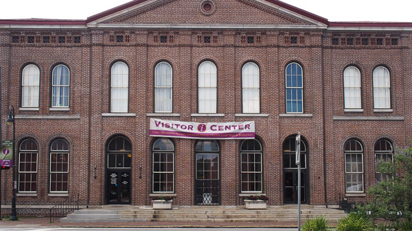
Savannah Visitor's Center
Visit the Visitors Center - 30 Min.
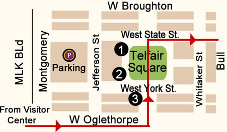
- From the Visitor's Center parking lot proceed to MLK Jr Blvd and turn left (North towards river).
- Walk 5 blocks and turn right on West Oglethorpe Avenue.
- Walk 3 blocks and turn left on Barnard Street.
- Walk 2 blocks to West York Street to Telfair Square.
- (0.4 Miles, 9 Minutes)
Telfair Square
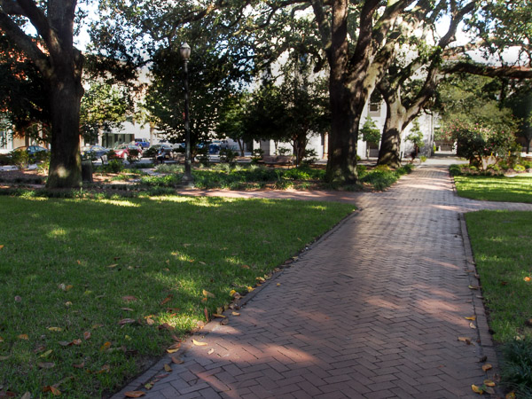
Telfair Square
Points of Interest:
 Trinity Methodist Church
Tours -Call the office at (912) 233-4766 to arrange a tour.
Office open Monday -Thursday 8:00a - 1:00p
 Telfair Academy of Arts & Sciences

Telfair Square was the last of four squares that was laid out in 1733, before James Oglethorpe returned to England for a visit. This square was name in honor of the Telfair family and their contributions to early Savannah history and culture. Telfair Square is located on Barnard, between State and York Streets.
Mary Telfair's brother, Alexander, built one of the beautiful and notable mansions at 121 Barnard Street. This home was deeded to the city upon her death and opened as the Telfair Museum of Arts and Sciences in 1886.
The historic Trinity Methodist Church is located at 127 Barnard on Telfair Square. This Greek Revival style church was built in 1848.
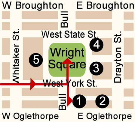
Leave Telfair Square and continue walking 2 blocks (East) on West York Street and Wright Square will be on the left (0.2 Miles, 4 Minutes)
Map (Telfair Square to Wright Square)
Wright Square *****
Points of Interest:
Juliette Gordon Low Birthplace (one block South of Wright Square)
Hours: March thru October:
Monday - Saturday 10:00a - 4:00p
Sunday 11:00a - 4:00p
Hours: November thru February:
Monday, Tuesday 10:00a - 4:00p
Thursday - Saturday 10:00a - 4:00p
Closed Wednesday
Sunday 11:00a - 4:00p
Ballastone Inn (Bed & Breakfast)
 Lutheran Church of Ascension - Open to the public from 9:00a - 2:00p

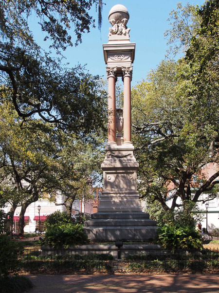
- Gordon Monument - Center of Wright Square
- Tomochichi Monument - Bull Street between West State and West York Streets on Wright Square
Wright Square is one of the original 4 Squares to be laid in 1733 by General Oglethorpe. Wright Square is located on Bull, between State and York Streets.
A courthouse has stood on this square since the time of Oglethorpe. Monthly auctions of livestock, government bonds, furniture and other goods were held in Wright Square.
Wright Square was the location of the Gallows in Colonial Savannah. The hangings which took place in Wright Square were public hangings. The first jail in historic Savannah was at the north end of Wright Square in the 1700's and 1800's. If any of the prisoners were sentenced to death they were sent to the gallows in Wright Square. After they were hung their bodies were simply buried right behind the gallows. Today, there is a CVS on the site of the jail and the Courthouse stands where the gallows once stood. The post office also stands on the square. It is located on the west side and was constructed in 1898. The current courthouse was built in 1889.
The Lutheran Church of the Ascension is located on the northeast trust lot. This is one of Savannah’s most loved churches and landmarks. It was built in the Norman and Gothic styles and has one of Savannah’s most dramatic church interiors. 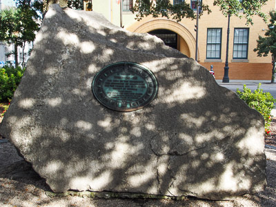
Tomo-Chi-Chi Monument Originally, the grave site of Chief Tomo-Chi-Chi, the Yamacraw chief who offered peace and cooperation with the settlers, occupied the center of Wright Square after his death in 1739. More than 100 years later, after William W. Gordon brought immense wealth to Savannah by constructing a railroad which brought cotton to the docks and wharves of Savannah from distant plantations, the Savanahians felt that he should be honored by a memorial in Wright Square. Therefore, they removed Tomo-Chi-Chi’s grave and replaced it with a monument to Gordon, which is there today.
Gordon's widow objected strongly to this perceived insult to Tomochichi. She and other members of the Colonial Dames of the State of Georgia planned to erect a new monument to Tomochichi. A massive piece of granite from Stone Mountain, purchased and planned by William Gordon’s widow and other members of the Colonial Dames of Georgia, was erected in 1899 to honor Tomochichi. Tomochichi was laid to rest on the southeast side of Wright Square.
Leave Wright Square heading North to East State Street and turn right (East).
Walk 2 blocks on East State Street to Oglethorpe Square. (0.2 Miles, 3 Minutes)
Oglethorpe Square
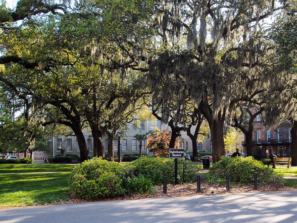
Oglethorpe Square

Points of Interest:
Owens-Thomas House
Hours:
Sunday & Monday 12:00p - 5:00p
Tuesday - Saturday 10:00a - 5:00p
(Last tour leaves at 4:30p)
- President's Quarters Inn (currently Bed & Breakfast) was originally twin Federal-style mansions built in 1855.
- Moravian Monument - A granite pedestal about four feet, shaped like a fluted column, with an inscribed bronze tablet mounted on a tabloid and placed in the northeastern section of Oglethorpe Square in 1933.
Oglethorpe Square was laid out in 1742 and was named in honor of Georgia founder General James Oglethorpe. At the northeast of the square is Owens-Thomas House. It is considered, both in its day and today, Savannah’s most sophisticated house.
The Presidents' Quarters Inn, a 16-room historic bed and breakfast, is located on the southeast side. Oglethorpe Square is located on Abercorn, between State and York Streets; President Street intersects east and west.
Oglethorpe Square was the final square of the six that James Oglethorpe laid out during the time that he resided in the colony
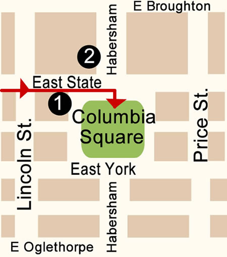
Leave Oglethorpe Square and walk 2 blocks (East) on East State Street to Columbia Square. (0.2 Miles, 3 Minutes)
Map (Oglethorpe Square to Columbia Square)
Columbia Square
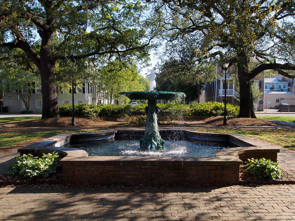
Wormsloe Fountain
Points of Interest:
Kehoe House (currently Bed & Breakfast)
Isaiah Davenport House -
Hours:
Monday - Saturday- 10:00a - 4:00p
Sunday - 1:00p - 4:00p
A guided tour takes 30 to 40 minutes
- Wormsloe Fountain- Center of Columbia Square
Columbia Square was laid out in 1799 and is named for Columbia, the poetic personification of the United States. It is located on Habersham, between State and York Streets. In the center of the square is a lovely cast iron fountain imported from the Wormsloe Plantation, the estate of Noble Jones, one of Georgia's first settlers. The fountain is decorated with vines, leaves, flowers, and other woodland motifs.
Columbia Square is a lovely square shaded by four giant live oaks. Nearby is the Davenport House, built in 1812, Victorian Mansion and The Kehoe House which was built in 1892.
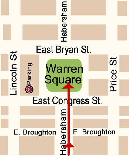
Leave Columbia Square on the North side and walk 4 blocks North on Habersham Street to Warren Square. (0.2 Miles, 3 Minutes)
Map (Columbia Square to Warren Square)
Warren Square
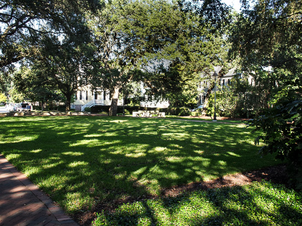
Warren Square
Points of Interest:
- Spencer House - 22 Habersham Street. Built sometime after 1790 and before 1804.
Warren Square was laid out after the final departure of James Oglethorpe and after the American Revolution in 1790. This square was named for General Joseph Warren, a Revolutionary War hero who was killed at the Battle of Bunker Hill. Warren Square is located on Habersham, between Bryan and Congress Streets. There are a number of historical homes near Warren Square. Many homes which were threaten with demolition were brought to Warren Square.
At 22 Habersham Street near Warren Square, George Basil Spencer had a post-colonial home built sometime after 1790 and before 1804. This was one of the most elaborate houses of its day.
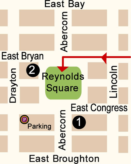
Leave Warren Square at East Bryan Street and walk 2 blocks to Reynolds on the left. (0.2 Miles, 4 Minutes)
Map (Warren Square to Reynolds Square)
Reynolds Square
Points of Interest:
Lucas Theatre
Tours are available Wednesday – Saturday, 10:00a – 4:00p
Guided tours are $5 per person and available by walk-up if events allow.
The tours take approximately 20 minutes
Olde Pink House (Is currently a Restaurant)
- Monument to John Wesley Founder of Methodism - Center of Reynolds Square
Reynolds Square was laid out in 1734 and was named for Capt. John Reynolds, governor of Georgia in the mid-1750's. A bronze statue honoring John Wesley, founder of Methodism stands in the center of the square. It is located on Abercorn, between Bryan and Congress Streets.
There are two homes of interest near Reynolds Square. The Pink House, built in the 18th century and the Oliver-Sturgis House, built in the 19th century. Today the Pink House located at 23 Abercorn Street is a fine restaurant.
Also found on Reynolds Square is the Lucas Theater, located at 22 Abercorn Street. This theater was built in 1921 and was originally designed for silent films and vaudeville and was eventually refitted for “talkies”. It was about to be demolished until a public-private partnership was formed to modernize and restore it.
From Reynolds Square exit on East Bryan and continue walking 2 blocks to Johnson Square. (0.1 Miles, 3 Minutes)
Map (Reynolds Square to Johnson Square)
Johnson Square *****
Monument to Maj. Gen. Nathanael Greene

Points of Interest:
- Monument to Maj. Gen. Nathanael Greene - Center of Johnson Square
Johnson Square was laid out in 1733 and was the first of the original squares and is still the largest. Johnson Square is located on Bull, between Bryan and Congress Streets.
Johnson Square has two fountains and a sundial. The original sundial was replaced in 1933 and it still sits today on the south side of the square. You can also find a plaque and mosaic map of the early city in Johnson Square. There is also a white marble bench in Johnson Square which pays tribute to Johnny Mercer, Savannah's popular and successful songwriter.
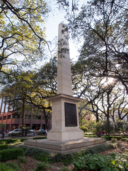
Johnson Square contains a tall white obelisk memorializing the Revolutionary War hero Nathanael Greene. The cornerstone was laid in 1825. Greene, who was originally buried in the Colonial Park Cemetery, was re-interred under this monument in 1902.
On the east side of Johnson Square is the Christ Church (now known as Christ Episcopal Church), called the Mother Church of Georgia. This was the first church in historic Savannah
Another landmark of Johnson Square includes the Johnson Square Business Center. This building, formerly known as the Savannah Bank Building, was the city's first "skyscraper", built in 1911. Johnson square is known as the financial district, or banking square, and many of the City's financial services companies are located here
From Johnson Square turn left on West Bryan Street and walk 2 blocks to Ellis Square. (0.2 Miles, 3 Minutes)
Map (Johnson Square to Ellis Square)
Ellis Square
Water Fountain

Points of Interest:
- The Fountains at Ellis Square
- Small sculptor of Johnny Mercer
Ellis Square, the city's second largest, was among the first four squares plotted by James Edward Oglethorpe in 1733. It was named for Sir Henry Ellis, Georgia's second royal governor. It is located on Barnard between Bryan and Congress Streets.
Since 1872, it was home to the City Market where farmers sold crops directly to shoppers. It was also known as Marketplace Square because it was the center of commerce from the 1730's through the 1950's. Prior to Union General Sherman's arrival in December 1864 it was also the site of a slave market.
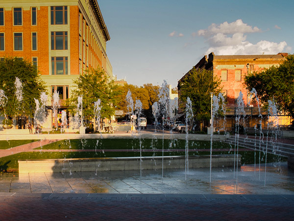
In 1954 Ellis Square was demolished to make way for a new four-story parking garage. This loss motivated the citizens to organize Savannah's historic preservation movement and today Ellis Square has been resurrected. The city spent nearly $32 million and more than four years bringing back the 1.5-acre square.
The fountains in Ellis Square are probably the most modern in the Squares. Shooting water straight up into the air from underground, the jets of water dance around in random patterns. At night, the lights are turned on the fountain, making the jets of water colorful. Most nights the fountain is turned off at 10:00p.
On the west side of Ellis Square is a small sculpture of Johnny Mercer.
From Ellis Square continue walking 2 blocks on East Saint Julian through the City Market to Franklin Square. (0.1 Miles, 2 Minutes)
Map (City Market to Franklin Square)
Franklin Square
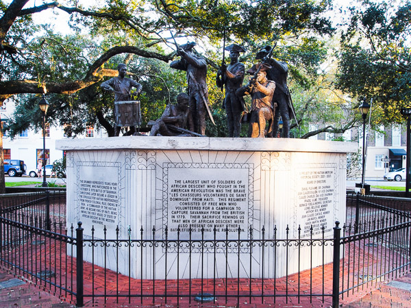
Chasseurs volontaires de Saint-Domingue Monument
Points of interest:
First African Baptist Church - 23 Montgomery Street
- Chasseurs-Volontaires de Saint-Domingue Monument - Center of Franklin Square
Franklin Square was established in 1790 along Montgomery Street between Congress Street and Bryan Street and was named after Benjamin Franklin.
On the west side of the square at 23 Montgomery Street is the First African Baptist Church, recognized as the oldest black Christian congregation in the country. The church was organized in 1788, 12 years before the first Baptist church for whites was built in Savannah.
Franklin Square was destroyed in 1935 when Montgomery Street became a federal route, but the square and much of the surrounding area were restored in the 1980s to commemorate the 250th anniversary of the founding of Georgia.
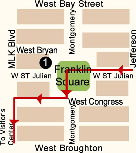
Exit Franklin Square on West Congress Street and turn right.
Walk 1 block to MLK Blvd and turn left.
Walk 6 blocks to Visitors Center. (0.4 Miles, 9 Minutes)
Map (Franklin Square to Visitor's Center)
For evening activities, choose one or more of the following:
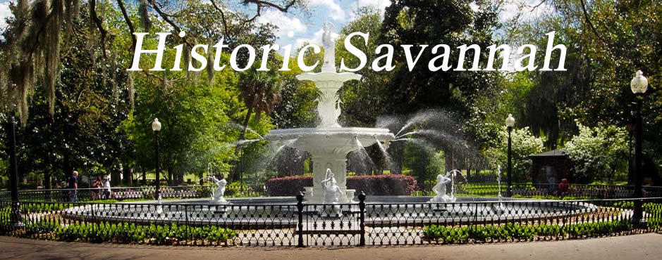
- Visit the Riverfront again (North end of the Historic District, on the River).
- Take one of the many Ghost Tours (tickets can be purchased on River Street and across from the Visitor's Center).
- Catch a show at the Old Savannah Theater (Chippewa Square, Bull Street at Hull Street).
- Spend time at Forsyth Park (South end of Historic District, Corner of Bull and Gaston Streets).